Observed Sea-Level Changes and Their Causes
Understanding the sources of this sea-level rise is important for improving confidence in future projections. The national sea level observing system in Norway is maintained and operated by the Norwegian Mapping Authority.
Instrumental records of sea-level change are available from tide gauge measurements, which, in a handful of locations, date back to the 1700s. For the last few decades, we have also have observations from satellite altimetry. Tide gauges measure relative sea-level changes at the coastline. Whereas satellite altimetry measures sea surface heights primarily in the open ocean.
Global sea-level change
As mentioned, only a few tide gauge records date back several centuries, for example, one of the longest continuous records is from Stockholm where measurements started in 1774. Today there are hundreds of tide gauge observations from across the globe that are available for analysis.
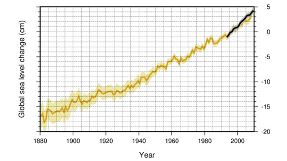
Using records from the global tide gauge network, scientists have applied different methods for reconstructing global sea-level rise over the past hundred years or so. This is a challenging task owing to the sparse spatial coverage of the observations (being limited to the coasts and some islands) and the fact that many records have data gaps.
In context of past changes, paleo observations show that global sea level has been relatively stable over the past ~3,000 years before beginning to accelerate in the late 19th century (Kopp et al., 2016).
In the Fifth Assessment Report of the IPCC, estimates using data from the global tide gauge network indicate that the rate of global sea-level rise was 1.7 ± 0.2 mm/yr between 1901 and 2010 (Rhein et al., 2013). The report also concludes that rate of sea-level rise has likely accelerated over this period. Between 1993 and 2010, over which time satellite altimetry observations are also available, global sea-level rise is estimated to have risen at a higher rate of ~3.2 mm/yr.

Understanding the sources of this sea-level rise is important for improving confidence in future projections. Measurements show that ocean thermal expansion and melting glaciers were the major drivers of 20th century global sea-level rise (Church et al., 2013).
Since the early 1990s, however, the contributions from the Greenland and Antarctic ice sheets have increased, raising concerns that these large ice masses are now stirring into life as global temperatures warm. In the long-term, it is expected that the ice sheets will be the dominant contributor to future sea-level rise under sustained warming.
Sea-level changes in Norway
The national sea level observing system in Norway is maintained and operated by the Norwegian Mapping Authority. It is comprised of the national tide gauge network and a number of different geodetic observations. There are 23 permanent tide gauges on mainland Norway; a few have been in operation since the late 19th century, while others were only recently established in the 1990s.
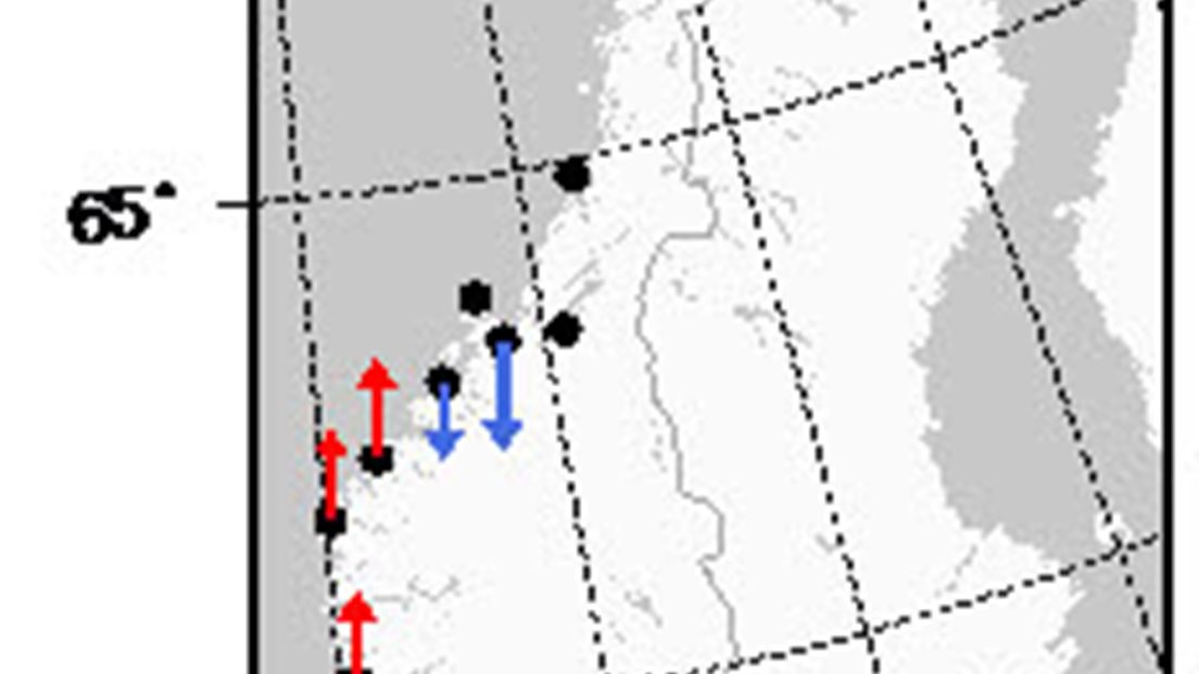
Observed rates of relative sea level change along the Norwegian coast show considerable spatial variability largely due to glacial isostatic adjustment (Simpson et al., 2015). For the period 1960 to 2010, about half of the tide gauges in Norway measured a relative sea-level fall, while the other half measured a moderate rise.
In locations such as Oslo and the middle part of Norway, relative sea level is currently falling because the rate of land uplift is greater than the rate of sea surface rise.
Whereas, for some places in the north and areas on the south and west coast, for example in Kristiansand and Stavanger, the opposite is true. Here sea level is now rising and this represents a reversal of the general trend of relative sea-level fall that has occurred in much of Scandinavia over the past ~10,000 years.

Using geodetic observations, it is possible to correct the tide gauge measurements for glacial isostatic adjustment to get an estimate of how fast sea surface heights are rising across Norway. The most recent estimate gives the rate of sea surface rise along the Norwegian coast as 1.9 ± 0.2 mm/yr from 1960 to 2010 (Simpson et al., 2015). The rate of sea-level rise in Norway is therefore similar to the global average rise.
Ocean temperature measurements indicate that thermal expansion contributed between 0.5 and 1 mm/yr to the observed rise between 1960 and 2010 (Richter et al., 2012). Estimates of the regional contribution from ice melt vary between 0.5 and 0.9 mm/yr over similar periods. Local changes to other physical quantities like the saltiness of seawater, atmospheric pressure and the wind also play a role in decadal-scale sea-level changes.
References
J. A., Church, N.J. White. (2011). Sea-Level Rise from the Late 19th to the Early 21st Century. Surv. Geophys, 32, 585-602, doi:10.1007/s10712-011-9119-1.
J.A. Church, P.U. Clark, A. Cazenave, J.M. Gregory, S. Jevrejeva, A. Levermann, M.A. Merrifield, G.A. Milne, R.S. Nerem, P.D. Nunn, A.J. Payne, W.T. Pfeffer, D. Stammer and A.S. Unnikrishnan (2013a): Sea Level Change. In: Climate Change 2013: The Physical Science Basis. Contribution of Working Group I to the Fifth Assessment Report of the Intergovernmental Panel on Climate Change [Stocker, T.F., D. Qin, G.-K. Plattner, M. Tignor, S.K. Allen, J. Boschung, A. Nauels, Y. Xia, V. Bex and P.M. Midgley (eds.)]. Cambridge University Press, Cambridge, United Kingdom and New York, NY, USA
R.E. Kopp, A.C. Kemp, K. Bittermann, B.P. Horton, J.P. Donnelly, W.R. Gehrels, C.C. Hay, J.X. Mitrovica, E.D. Morrow, S. Rahmstorf (2016). Temperature-driven global sea-level variability in the Common Era, P. Natl. Acad. Sci. USA, 113, E1434–E1441, doi:10.1073/pnas.1517056113, 2016.
M. Rhein, S.R. Rintoul, S. Aoki, E. Campos, D. Chambers, R.A. Feely, S. Gulev, G.C. Johnson, S.A. Josey, A. Kostianoy, C. Mauritzen, D. Roemmich, L.D. Talley, F. Wang (2013). Observations: Ocean. In: Climate Change 2013: The Physical Science Basis. Contribution of Working Group I to the Fifth Assessment Report of the Intergovernmental Panel on Climate Change [Stocker, T.F., D. Qin, G.-K. Plattner, M. Tignor, S.K. Allen, J. Boschung, A. Nauels, Y. Xia, V. Bex and P.M. Midgley (eds.)]. Cambridge University Press, Cambridge, United Kingdom and New York, NY, USA.
K. Richter, J.E.Ø. Nilsen, H. Drange (2012). Contributions to sea level variability along the Norwegian coast for 1960-2010. J. Geophys. Res., 117, doi:10.1029/2009JC007826
M. J. R. Simpson, J. E. Ø. Nilsen, O. R. Ravndal, K. Breili, H. Sande, H. P. Kierulf, H. Steffen, E. Jansen, M. Carson, O. Vestøl (2015). Sea Level Change for Norway: Past and Present Observations and Projections to 2100. Norwegian Centre for Climate Services report 1/2015, ISSN 2387-3027, Oslo, Norway.

The mail has been sent!