Defining Sea Level and Understanding its Causes
For effective coastal management, it is important to understand how sea levels will change in the future.
Changes to sea level, storm surges and/or wave events will lead to changes in coastal impacts. These changes represent a changing exposure or risk to our society.
Coastal management
In the global setting, Norway is considered to have a low physical vulnerability to sea-level rise (Aunan and Romstad, 2008). This is because many areas of the coastline have a steep topography with rock types that are resistant to erosion. The land is also uplifting which acts to mitigate climate driven sea-level rise.
Although this general perception may be true, there are nevertheless several reasons why we need a good understanding of future sea-level changes and their associated risks.
Firstly, as highlighted in a national vulnerability assessment, there are low-lying coastal areas of Norway that could be at risk owing to their important cultural and economic value (Aunan and Romstad, 2008). All of Norway's major cities are situated along the coast and, in recent years, some have undertaken large developments close to the shoreline. Nationwide there are around 87,000 buildings situated less than 1 m above sea level.
Secondly, it is prudent to take into account our changing climate in planning and/or adaption policy. Sea level in Norway has been relatively stable or falling in the recent past but now we are entering a period where we see an acceleration in global sea-level rise. As a coastal nation, the implications of these issues will need to be carefully thought about.
Defining sea level and observation systems
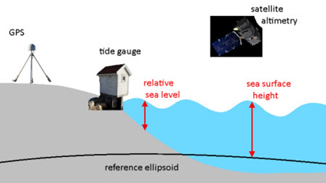
Determining sea-level changes can be thought about in two separate ways:
Relative sea level is the measure of the sea surface with respect to the seafloor and the shore. It is changes in relative sea level that are of interest for coastal planning and adaption. We measure relative sea-level changes using tide gauges. The longest tide gauge records in Norway extend from the late 1800s to present-day. In Scandinavia, land uplift due to glacial isostatic adjustment is an important factor when assessing relative sea-level changes at the coastline. Today we are able to use satellite based observations such as GPS to provide a measure of land uplift.
Sea surface height is the measure of the sea surface with respect to a reference ellipsoid or Earth's centre of mass. Satellite altimetry provides a measure of sea surface heights but these data are only available for the past couple of decades or so. For observations like satellite altimetry and GPS, we are interested in measuring changes at a submillimeter precision. This is hugely challenging as we live on a dynamic Earth that is constantly changing. Being able to quantify and relate these observations in space and time, and at a high degree of precision, is made possible by a branch of science called geodesy. Geodesy therefore plays a key role in understanding sea-level change (see Tamisiea et al. (2014) for a nice review).
The Norwegian Mapping Authority is responsible for the operation of the ground-based sea level observing system in Norway, that is, the GPS and tide gauge networks.

Processes affecting sea level
As global temperatures have increased, global sea level has risen in response to increased ocean temperature (thermal expansion of seawater) and the melting of glaciers and ice sheets. This is what we have observed over the 20th century and what we expect will continue over the next 100 years and beyond.
A common misconception, however, is that this sea-level rise has been equally large everywhere, much like filling up water in a bathtub. In fact, there are large regional differences in sea-level rise caused by a number of different physical processes. Taking account of these different processes is important when trying to better understand and project sea-level changes on a local or regional scale.

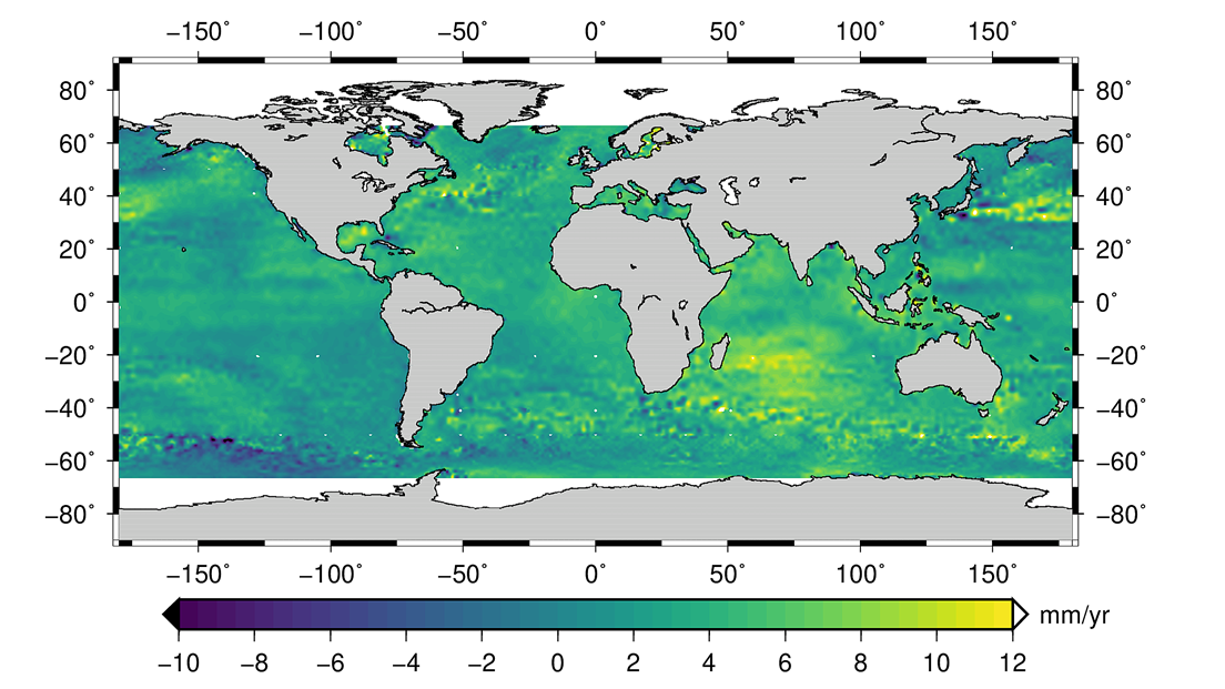
The picture above shows measured sea surface height changes over the period 1992 to 2018. The pattern we see largely reflects spatial differences in changes to ocean temperatures. On these timescales, the regional changes in ocean temperatures, and hence sea level, are driven by both non-uniform warming and wind driven changes in ocean circulation. But changes to the saltiness of seawater, the amount of rainfall over land are also significant over periods of years to decades.
Over longer timescales other processes will come into play and alter the pattern of sea-level rise. The melting of glaciers and ice sheets, for example, changes the amount of water in the oceans – this movement of mass leads to a change in the rotation and gravitational pull in different parts of the Earth, which has implications for sea level. And, as mentioned, when assessing relative sea-level changes at the coastline, an important factor for Norway to consider is land uplift due to glacial isostatic adjustment.
Understanding sea-level change, therefore, is challenging because it involves so many different scientific disciplines. This is also part of the reason why it is interesting (!) and requires close cooperation from scientists with a variety of backgrounds.
References
Almås, AJ and Hygen, HO. (2012). Impacts of sea level rise towards 2100 on buildings in Norway, Building Research & Information, 40:3, 245-259
Aunan, K. and Romstad, B. (2008). Strong coasts and vulnerable communities: potential implications of accelerated sea-level rise for Norway. Journal of Coastal Research, 24(2), 403–409. West Palm Beach (Florida), ISSN 0749-0208.
Tamisiea ME, Hughes CW, Williams SDP, Bingley RM. (2014). Sea level: measuring the bounding surfaces of the ocean. Phil. Trans. R. Soc. A 372: 20130336. http://dx.doi.org/10.1098/rsta.2013.0336

The mail has been sent!